#MineAlert allows you to track & share mining applications & licences
#MineAlert allows you to track & share mining applications & licences
Who is ScienceLink?
Science communication is about connecting science to society, and about making data, research, recommendations and technical information accessible to broader audiences – linking researches to their audience using both the latest digital platforms and traditional media. ScienceLink uses Esri technology to reach an online audience through an interactive digital map viewer. One such project is #MineAlert.
What is #MineAlert?
The Oxpeckers Centre for Investigative Environmental Journalism combines traditional investigative reporting with data-driven journalism, cutting-edge geo-narrative techniques, and digital engagement tools. Oxpeckers operates a core newsroom, bolstered by Oxpecker Fellows, and a range of special digital projects designed to create public resources to improve citizen access to environmental justice.
The #MineAlert project builds on this legacy by mapping mining plans and making available related licences, in order to enable citizens and communities to participate meaningfully in decision-making processes, track the progress of mining projects, notify stakeholders and authorities if something seems amiss, and take preventative measures to avoid exposure to possible risks.
The Goal of #MineAlert
#MineAlert is a website and app that alerts residents and organisations to mining applications and licences in their regions. It aims to promote public and private sector accountability in the mining sector, to advance civil society and socio-economic rights, to protect the free flow of information, and to strengthen justice and equality.
The Challenge
South Africa is a water-scarce country, and mining activity around the country poses a dire threat to what little water we have, in the form of acid mine drainage, toxic metal leaching, and wastage. Contamination from mining activity then goes on to destroy or destabilise ecosystems, as well as ending up in the water supply of South Africans, leading to health problems and rising economic and public health costs. Combatting this unseen menace requires data and information about mining and water quality to be publicly available to citizens, organisations and journalists.
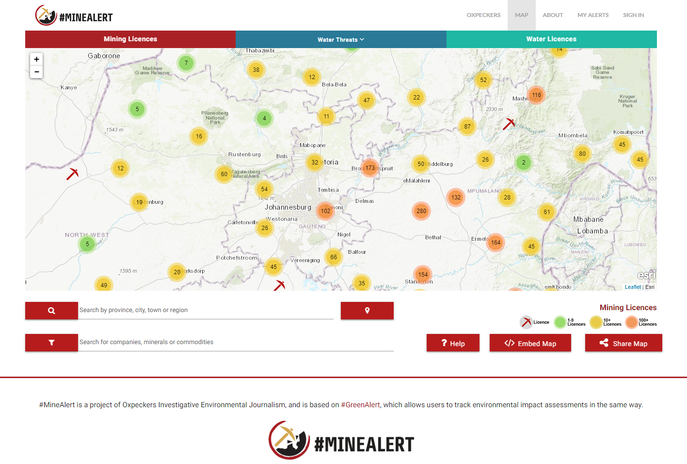
Below is an image of the #MineAlert Web Application Viewer:
The Challenge
– Data & information about mining activity to be publicly available to citizens, organisations and journalists.
The Solution
– The Oxpeckers Centre for Investigative Environmental Journalism undertook to make information from the Water Research Council’s Mine Water Atlas publicly accessible on Esri technology.