Adding value to environmental monitoring programmes
.
What is M.A.P Scientific Services (MAPSS)?
MAPSS is a classic university start-up that aims to find innovative and sustainable solutions for people, animals, and ecosystems to thrive in a rapidly changing world. MAPSS comprises a dynamic team of ecologists and GIS professionals geared towards solving problems. To achieve this they focus on conservation, ecological restoration, and sustainable development and utilise a combination of a talented team, current technology, internationally acknowledged best practice methodologies, collaborative solutions, and continued learning.
The Goal
Our aim is to bridge the gap between science and implementation. Although more data are collected now than ever before, it remains time consuming, expensive, and difficult to visualise and interpret these data. It is therefore not easy to turn raw ecological data into practical, evidence-based management actions.
The Challenge
On a daily basis, practitioners in the environmental field collect an invaluable amount of data. These data are supposed to help programme managers make informed decisions – for example, what management actions are required to help ecosystems reach a pre-defined “benchmark” which indicates programme success? However, the sheer volume of data, its storage, and ultimately its use is becoming problematic. Data are collected in a variety of ways on different variables (e.g. physical conditions, species composition, external exchanges, community structure, ecosystem function, and threats), which increases its complexity. Moreover, data management and subsequent analyses are then undertaken in multiple steps, involving many time consuming steps. Management of large and diverse datasets for reporting and modelling ecosystem processes are also demanding and may increase the probability of mistakes in data handling, analyses, and interpretation, which is ultimately not cost-effective. The sheer volume of data collected during the life of a project, its storage, and use could result in a shifting baseline effect – a generational amnesia due to lack of experience about past conditions – it is therefore essential that a system of continual “memory refreshment” is implemented and that progress is continually checked. Yet, few organisations have the capacity required to collect and interpret data correctly to formulate evidence-based management decisions.
The Solution
The MAPSS solution focuses on developing a customised tool that guides environmental monitoring organisations to adequately collect, store, analyse, and view ecological data to ensure scientifically sound outputs that inform decision making. We leverage Esri software and develop a platform that is based on four components: data input, data storage, data analyses, and data outputs. This solution is based on a spatial database which incorporates various forms of real world input data sources, for example: GPS tracking devices, environmental sensors, remotely sensed spatial layers, and direct observations. The spatial database collates these data and provides clients with a data management frontend to view, analyse, export, and interact with the data, and generate informative reports. Ultimately, our clients are provided with a tool that ensures quality data collection, and thus informative outputs that add value to environmental monitoring programmes.
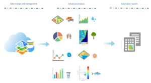
Figure 1. A conceptual model of the MAPSS solution. The solution allows for virtually unlimited storage capacity, backup and recovery, data consistency and integrity, advanced analyses, easy implementation of new algorithms, and integration of different data sources collected by environmental organisations. Outputs can be streamlined to automatically evaluate defined objectives and generate reports.
The Challenge
- Data are collected in different ways, on different variables by different people.
- Data are stored using a multitude of software and file formats.
- Analysis and reporting become time consuming and are not cost effective.
The Solution
A single, user friendly database and viewing platform based on ArcGIS that allow collection, storage, management, analyses, visualisation, and interpretation of data collected from multiple sources over space and time.
The Benefits
- Increased data consistency and integrity.
- Centralised control over different data sources.
- Advanced and automated analyses to evaluate objectives.
- Transparent reporting tool.
- Cost effective.
What is M.A.P Scientific Services (MAPSS)?
MAPSS is a classic university start-up that aims to find innovative and sustainable solutions for people, animals, and ecosystems to thrive in a rapidly changing world. MAPSS comprises a dynamic team of ecologists and GIS professionals geared towards solving problems. To achieve this they focus on conservation, ecological restoration, and sustainable development and utilise a combination of a talented team, current technology, internationally acknowledged best practice methodologies, collaborative solutions, and continued learning.
The Goal
Our aim is to bridge the gap between science and implementation. Although more data are collected now than ever before, it remains time consuming, expensive, and difficult to visualise and interpret these data. It is therefore not easy to turn raw ecological data into practical, evidence-based management actions.
The Challenge
On a daily basis, practitioners in the environmental field collect an invaluable amount of data. These data are supposed to help programme managers make informed decisions – for example, what management actions are required to help ecosystems reach a pre-defined “benchmark” which indicates programme success? However, the sheer volume of data, its storage, and ultimately its use is becoming problematic. Data are collected in a variety of ways on different variables (e.g. physical conditions, species composition, external exchanges, community structure, ecosystem function, and threats), which increases its complexity. Moreover, data management and subsequent analyses are then undertaken in multiple steps, involving many time consuming steps. Management of large and diverse datasets for reporting and modelling ecosystem processes are also demanding and may increase the probability of mistakes in data handling, analyses, and interpretation, which is ultimately not cost-effective. The sheer volume of data collected during the life of a project, its storage, and use could result in a shifting baseline effect – a generational amnesia due to lack of experience about past conditions – it is therefore essential that a system of continual “memory refreshment” is implemented and that progress is continually checked. Yet, few organisations have the capacity required to collect and interpret data correctly to formulate evidence-based management decisions.
The Solution
The MAPSS solution focuses on developing a customised tool that guides environmental monitoring organisations to adequately collect, store, analyse, and view ecological data to ensure scientifically sound outputs that inform decision making. We leverage Esri software and develop a platform that is based on four components: data input, data storage, data analyses, and data outputs. This solution is based on a spatial database which incorporates various forms of real world input data sources, for example: GPS tracking devices, environmental sensors, remotely sensed spatial layers, and direct observations. The spatial database collates these data and provides clients with a data management frontend to view, analyse, export, and interact with the data, and generate informative reports. Ultimately, our clients are provided with a tool that ensures quality data collection, and thus informative outputs that add value to environmental monitoring programmes.
Figure 1. A conceptual model of the MAPSS solution. The solution allows for virtually unlimited storage capacity, backup and recovery, data consistency and integrity, advanced analyses, easy implementation of new algorithms, and integration of different data sources collected by environmental organisations. Outputs can be streamlined to automatically evaluate defined objectives and generate reports.
The Challenge
- Data are collected in different ways, on different variables by different people.
- Data are stored using a multitude of software and file formats.
- Analysis and reporting become time consuming and are not cost effective.
The Solution
A single, user friendly database and viewing platform based on ArcGIS that allow collection, storage, management, analyses, visualisation, and interpretation of data collected from multiple sources over space and time.
The Benefits
- Increased data consistency and integrity.
- Centralised control over different data sources.
- Advanced and automated analyses to evaluate objectives.
- Transparent reporting tool.
- Cost effective.