National Spatial Planning Data Repository
The Challenge
No central repository for South Africa’s spatial data.
The Solution
Enables sharing of spatial information across all spheres of government and the private sector.
Benefits
-
Community GIS
-
Electronic Lodgement
Introduction
The Department of Rural Development and Land Reform (DRDLR) is a department of the South African government. It is responsible for topographic mapping, cadastral surveying, deeds registration and land reform.
The DRDLR’s aim of achieving integrated development through effective spatial planning and land use management gained urgency with the passing of the Spatial Planning and Land Use Management Act 16 of 2013 (SPLUMA).
Background
South Africa does not have a central repository which utilises spatial data for spatial planning, monitoring, evaluation and coordination purposes at a national level.
Problem Statement
Most departments have standalone databases and tools used for planning and reporting purposes. Planning is often done in isolation, leading to fragmented planning processes which are characterised by delays and misalignment. This affects integrated development planning across all spheres of government.
Many municipalities utilise manual methods to process land use applications. These systems are not integrated with broader land use management issues so as to yield optimal results. This causes undue delays regarding processing time, haphazard approvals or dismissals and incorrect land uses being allocated to a piece of land. Information, including spatial data, is not readily accessible to the relevant users and planning is often done in isolation, without taking into account the needs of and impacts from other services.
Objective
The aim of achieving integrated development through effective spatial planning and land use management gained urgency with the passing of SPLUMA in 2013. It mandates national government to develop mechanisms that will support and strengthen the capacity of provinces and municipalities with regard to the adoption and implementation of an effective spatial planning and land use management system. In line with this, the DRDLR embarked on a process to develop the National Spatial Planning Data Repository (NSPDR) Ecosystem.
NSPDR Ecosystem
The digital system enables SPLUMA by supporting and strengthening the capacity of provinces and municipalities. It improves integrated planning by creating an ecosystem for the real-time sharing of spatial data between various spheres of government, state-owned entities and the private sector.
E-Lodgement
This functionality seeks to address the absence of an automated system that can assist municipalities with the receiving and processing of land development applications. E-Lodgement facilitates the electronic lodgement, assessment and consideration of applications through a secure portal with an automated internal workflow.
The GIS Platform
The NSPDR Ecosystem was built using Esri’s ArcGIS Platform. The Esri South Africa and Agizo Solutions Joint Venture (JV) used the platform to develop a central repository that utilises spatial data for spatial planning, monitoring, evaluation and coordination purposes. An automated E-Lodgement facility was included in the digital ecosystem.
The diagram below unpacks the ArcGIS Platform into the various components, workflows and methods to show how each component contributes to the NSPDR Ecosystem.
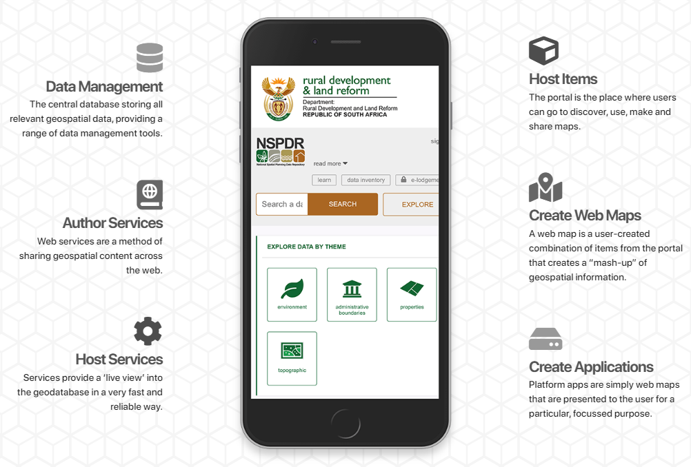
Data Management
The central database stores all relevant geospatial data and provides a range of data management tools.
Spatial data from a range of sources has been categorised into various themes and can be used to design customised data models and validations. A wide variety of geospatial and data management tools and features are available. The reference web maps are interactive and users can add data and make use of the online analytical tools and queries. Geoprocessing tools allow users to download extracted data and email the data as a compressed file. In addition, the comprehensive monitoring and evaluation dashboards make it easy for management to monitor contributions and data management from all departments.